логин
Звездные пользователи
Голосование
Дом
>
Балтимор
>
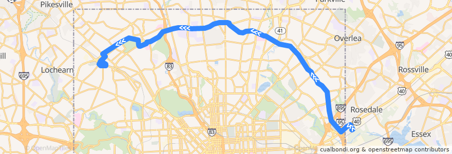
LocalLink 30: Rogers Avenue
маршрут
LocalLink 30: Rogers Avenue
напишите первый отзыв
Смотрите на интерактивной карте
Достопримечательности рядом с маршрутом
Mount Zion Baptist Christian School
Hillside Chapel
Baltimore Hebrew University
Lifebridge Pharmacy
Subway
Bank of America
Subway
Silver Queen Cafe
Church of the Transfiguration
Greater Church of the Risen Saviour
Emma's Tea Spot
Searchlight Training Center for Retarded Children
Kingdom Hall of Jehovahs Witnesses
Los Rancheros
Rogers Avenue Synagogue
Cedarcroft School
Foster Dental Group
Saint Paul & Biddle Medical Associates
Papa John's
Abundant Life Christian Church
Atwater's Cafe
Hamilton Business School
Strand Theatre Co.
KFC/Long John Silver’s
Zen West Roadside Cantina
Church of the Redeemer Day School
House of Praise
Drivers Edu Driving School
Greenspring Cafe
Chofetz Chaim Synagogue
BB&T
CVS Pharmacy
Garden Sea Chinese Restaurant
Greater Grace Christian Academy
Saint Marys Seminary
Dayspring
Church of the Redeemer
Mount Carmel Church of God in Christ
Peking Court
Curran's Delly
Arlington Methodist Church
Kerygma Baptist Church
Pharmacy
Pizza Mart
Andrew Chapel United Methodist Church
Bethel World Outreach Center
Subway
Prine Care Pharmacy
Govans Presbyterian Preschool
A-1 Sushi
Hub Sports Bar & Grill
First Christian Community Baptist Church
Liberty Bank
Sofi's Crepes
Grace United Methodist Preschool
Moravia Park Primary School
Chung Mee
McDonald's
Dunkin' Donuts
Baltimore Fire Station 2
Остановки:
Northern Parkway & Park Heights Westbound
Northern Parkway & York Road Near-side Westbound
Northern Parkway & York Road Far-side Westbound
-76.62475090000001, 39.362114600000005
-76.63408050000001, 39.3621427
Northern Parkway & Park Heights Avenue Westbound Far-side
Northern Parkway & Park Heights Westbound
Belvedere Avenue & Preakness Way Westbound Near-side
Belvedere Avenue & Lanier Avenue Opposite Westbound
Pulaski Highway & 62nd Street Westbound
Preakness Way Between Northern Parkway & Belvedere Avenue Northbound
-76.5301585, 39.3102005
-76.6643732, 39.353523
Pulaski Highway & 62nd Street Westbound
Falls Road & Northern Parkway Southbound
Belvedere Avenue & Lanier Avenue Opposite Westbound
Northern Parkway & Charles Street Westbound
-76.6459322, 39.361534500000005
Northern Parkway & Springlake Way Westbound
Belvedere Avenue & Preakness Way Westbound Near-side
Preakness Way Between Northern Parkway & Belvedere Avenue Northbound
Northern Parkway & Roland Avenue Westbound
Northern Parkway & Park Heights Avenue Westbound Far-side
Rosedale Industrial Park
-76.60951200000001, 39.365116300000004
Northern Parkway & York Road Westbound
-76.6174079, 39.3643504
-76.53009990000001, 39.310148000000005