Login
Star users
Poll
Home
>
Baltimore
>
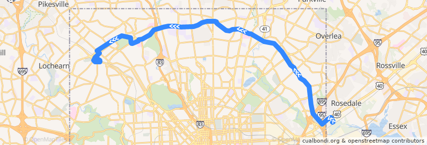
LocalLink 30: Rogers Avenue
Route
LocalLink 30: Rogers Avenue
write the first review
See in interactive map
Points of interest near the route
Church of the Transfiguration
Prine Care Pharmacy
Subway
House of Praise
Hub Sports Bar & Grill
Best Pizza Subs Wings & More
Garden Sea Chinese Restaurant
Searchlight Training Center for Retarded Children
Holy Trinity Ministries
Foster Dental Group
Rite Aid
BB&T
Hamilton Business School
Gil's Pizza
Dayspring
Moravia Park Primary School
Subway
Pizza Mart
Baltimore Fire Station 2
Los Rancheros
Church of the Redeemer
Saint Marys Seminary
Pizza Bravo Plus
Govans Elementary School
American Buffalo Wings
Fast Wok
Govans Presbyterian Preschool
Liberty Bank
Cedarcroft School
Baltimore Hebrew University
McDonald's
Adventure Dental & Orthodontics
Elderslie Methodist Church
Saint Paul & Biddle Medical Associates
Church of the Redeemer Day School
Arlington Methodist Church
Beth Jacob School
Peking Court
Rogers Avenue Synagogue
Pharmacy
Curran's Delly
Andrew Chapel United Methodist Church
KFC/Long John Silver’s
Café Zen
Greater Church of the Risen Saviour
Emma's Tea Spot
Kerygma Baptist Church
Greater Grace Christian Academy
Lifebridge Pharmacy
Lost In The 50's
Char'd CIty
Silver Queen Cafe
Hamilton Presbyterian Church
Bank of America
First Christian Community Baptist Church
Papa John's
Greenspring Cafe
Bethel Temple Church of Christ
Abundant Life Christian Church
Grace United Methodist Preschool
Stops:
-76.6459322, 39.361534500000005
Northern Parkway & York Road Near-side Westbound
Pulaski Highway & 62nd Street Westbound
-76.6174079, 39.3643504
-76.62475090000001, 39.362114600000005
Rosedale Industrial Park
Falls Road & Northern Parkway Southbound
Northern Parkway & Park Heights Avenue Westbound Far-side
Northern Parkway & Park Heights Avenue Westbound Far-side
Preakness Way Between Northern Parkway & Belvedere Avenue Northbound
Belvedere Avenue & Lanier Avenue Opposite Westbound
-76.53009990000001, 39.310148000000005
Northern Parkway & York Road Westbound
Northern Parkway & Park Heights Westbound
-76.60951200000001, 39.365116300000004
-76.6643732, 39.353523
Northern Parkway & Springlake Way Westbound
Preakness Way Between Northern Parkway & Belvedere Avenue Northbound
Pulaski Highway & 62nd Street Westbound
-76.5301585, 39.3102005
Northern Parkway & York Road Far-side Westbound
Northern Parkway & Roland Avenue Westbound
Northern Parkway & Charles Street Westbound
Belvedere Avenue & Preakness Way Westbound Near-side
Belvedere Avenue & Preakness Way Westbound Near-side
Belvedere Avenue & Lanier Avenue Opposite Westbound
Northern Parkway & Park Heights Westbound
-76.63408050000001, 39.3621427