로그인
스타 사용자
투표
홈페이지
>
Mesa County
>
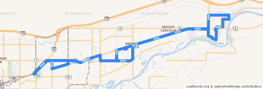
Route 4 - Palisade
노선
Route 4 - Palisade
첫 번째 리뷰 작성
여행지
Clifton
Palisade
대화식지도에서보기
루트 근처의 관심 지점
357 Bar & Grill
Plum Creek Winery
Palisade Library
Red Fox Cellars
Cedar Point Health - Urgent Care
Chin Chin Chinese Restaurant
Papa Murphy's
Palisade Pharmacy
Papa John's
Maison la Belle Vie Winery
Talon winery
Palisade
Meadery of the Rockies
Mesa County Library Clifton Branch
Palisade Livery
Jimmy John's
Graystone Winery
Marilac Clinic
Inari's
버스 정류장:
Highway 6 + West of 33 Road (NO SIGN)
34 Road + South of Highway 6
1st Street + East of Victoria Drive
Highway 6 + West of 36 Road (Church)
Highway 6 @ Mount Garfield Middle School (Inside Parking Lot)
Upper Iowa Avenue
Clifton Transfer Station
Rodeo Road + West of Logan Street
35 Road + South of Highway 6
Kluge Avenue + South of 4th Street
Bower Avenue + North of 2nd Street
Iowa Avenue + South of Frontage Road
1st Street + East of Majestic Court (by the brick wall)
Front Street + East of 3rd Street
3rd Street + East of Main Street
Highway 6 + East of Lois Street (NO SIGN)
Elberta Street + North of Crawford Lane
7th Street + West of Peach Avenue (East Valley School)
F Road + West of 35 Road
1st Street + Grand Avenue
Elberta Street + North of Highway 6 (Colorado National Bank)
Highway 6 + West of 35 1/2 Road
Elberta Avenue + South of Frontage Road
Iowa Avenue + North of Pendleton Street
34 1/2 Road + North of F Road (Peachtreet/Blossom Care Center)
F Road + East of 34 1/2 Road (Peachtree/Blossom Care Center)
Highway 6 @ Palisade High School (Inside Parking Lot)
Front Street + West of 33 Road